Pwosesis Priyorite Pwojè 2025
Lis Pwojè Priyorite a gen yon lis pwojè otowout, transpò piblik, bisiklèt, ak pyeton ki pa gen finansman ki te priyorite pou finansman. Lis la mete ajou chak ane, sa ki pèmèt gouvènman lokal yo planifye pou finansman ak aplikasyon pwojè nan kominote respektif yo. Priyorite yo baze sou kritè etabli tankou volim trafik, enpak anviwonmantal, ak fon lokal ki disponib.

The Heartland Regional Transportation Planning Organization (HRTPO) coordinates transportation plans for the Heartland region of Florida, including the six counties of DeSoto, Glades, Hardee, Hendry, Highlands, and Okeechobee, and the urbanized area of Highlands County, including the cities of Sebring and Avon Park. The HRTPO provides the forum for local elected officials, their staff, and industry experts, and the public to work together to improve transportation in the Heartland Region. As the metropolitan planning organization for the Heartland of Florida, the HRTPO is preparing the region’s third Long Range Transportation Plan (LRTP) with the horizon year of 2050.
The 2050 Long Range Transportation Plan (LRTP) is a multimodal transportation plan that will identify current and anticipated transportation needs in the Heartland Region for the next 20+ years. It considers all modes of transportation, including motorized vehicles, public transportation, bicycles, walking, freight and goods movement, and air travel.
What We Heard

Safety concerns on major corridors and within town centers
Across the Heartland Region, comments often referenced concerns about high speeds, frequent crashes, and stressful travel conditions on major corridors that also function as local main streets in some communities. In towns, people also expressed concern about safe crossings and conditions for walking and bicycling.

The LRTP is the adopted, performance based, financially constrained blueprint that connects goals to measurable outcomes and provides the required basis for programming projects, demonstrating fiscal constraint, coordinating with state and transit performance plans, and maintaining eligibility for federal transportation funding.
People & Places


The counties of the Heartland share a rich cultural history and unique natural resources that provide dynamic opportunities and challenges in the coming decades. The six HRTPO counties are within the South-Central Rural Area of Opportunity (RAO), which is defined as a region composed of rural communities that have been adversely affected by extraordinary economic events or natural disasters and designated as such by the State of Florida.
Across the Heartland counties, residents consistently describe transportation as a key factor in quality of life, and they show a clear desire to strengthen mobility options in practical, community-centered ways. People value the region’s connected small towns and rural character, but they also emphasize that daily life is highly car-dependent and that many households, especially older adults, people with disabilities, and residents without reliable vehicles, face real barriers reaching jobs, healthcare, groceries, and community activities.
Document Links

Explore the Map Gallery
Regional Transportation Network

The Regional Roadway Network for the Heartland region consists of roadways of regional significance, including facilities that are part of the Strategic Intermodal System (SIS) as well as non-SIS roads, both on and off the state highway system. Together, these roads form an interconnected network that links cities and crosses county boundaries, serves a high volume of motorists, and provides access to major activity centers and public facilities.
In addition to the Regional Roadway Network, the Heartland region is connected through other transportation modes, including limited public transportation, bicycle and pedestrian systems, airports, rail, and freight. . These modes of transportation provide connections within the Heartland region as well as linkages to adjacent regions, the state, and the country as well as globally.
Public input reflects optimism that targeted improvements can make a meaningful difference. Residents point to opportunities to build existing services (such as coordinated transportation and paratransit), improve awareness of available options, and explore modest, high-impact transit solutions.
Goals and Strategies

Safe | Eliminate traffic fatalities and serious injuries on all public roads while increasing security for all.
-
Address High-Crash Locations: Prioritize projects that improve safety in high crash locations and corridors
-
Emergency Preparedness: Provide safe and reliable transportation options during emergencies
-
System Security: Increase the security of the transportation system for both motorized and non-motorized users
-
Safety Education: Support and promote driver, bicycle, and pedestrian safety education.
Connected | Enhance the integration and connectivity of the transportation system, across and between modes, for people and freight.
-
Multimodal Accessibility: Plan and design multimodal transportation systems that are accessible to all users.
-
Goods Movement: Improve connections to ports, rail, airports, and intermodal logistics facilities for efficient freight movement.
-
Regional Connectivity: Strengthen connections between major activity centers within the Heartland Region
-
Travel & Tourism: Enhance travel and tourism by improving the user experience and promoting regional attractions.
Quality | Maintain and develop transportation options that are in good repair, user-friendly, and supportive of healthy, active lifestyles.
-
Public Involvement: Encourage early and proactive public engagement, offering diverse opportunities for participation.
-
Congestion Reduction & Reliability: Reduce congestion and promote system reliability.
-
Land Use Coordination: Coordinate land use and transportation planning to support multiple modes.
-
Efficient Operations: Promote efficient system management and operations.
Resilient | Improve the resiliency and reliability of the transportation system for today and in the future, while protecting the environment and supporting economic vitality.
-
Optimize Existing Facilities: Maximize the use of current transportation infrastructure.
-
Stormwater Management: Reduce or mitigate stormwater impacts from surface transportation.
-
Economic Competitiveness: Support the region’s economic vitality by enabling competitiveness, productivity, and access to trade markets.
-
Environmental Stewardship: Minimize and mitigate air and water quality impacts, and protect and preserve the environment.
-
Regional Consistency: Align with the Heartland 2060: Building a Resilient Region Plan and other relevant regional plans.
Future Conditions
Assessment of capital investment and other strategies to preserve the existing and projected future metropolitan transportation infrastructure, provide for multimodal capacity increases based on regional priorities and needs, and reduce the vulnerability of the existing transportation infrastructure to natural disasters. The metropolitan transportation plan may consider projects and strategies that address areas or corridors where current or projected congestion threatens the efficient functioning of key elements of the metropolitan area's transportation system.

On the non-Strategic Intermodal System (Non-SIS), the 2050 analysis identified six roadway segments where forecast traffic demand exceeds (or closely approaches) the practical capacity of the existing facility resulting in volume-to-capacity (V/C) ratios from 1.10 to 1.30. Four of the constrained segments are in Highlands County and are best suited for congestion management and operational strategies, while two segments on Kings Highway in DeSoto County indicate a need for added through-lane capacity (widening from 2 lanes to 4 lanes, A2–4) to address projected deficiencies. Due to constraints in funding availability, the segment identified as SW Glenadine to Peace River Street has been split into two segments. These findings help focus the LRTP’s Non-SIS discussion on the specific corridors most likely to experience recurring congestion by 2050, while keeping flexibility to refine solutions through project development, corridor studies, and local context.
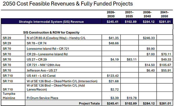
Revenue Forecast & Funding Plan
The Long Range Transportation Plan (LRTP) includes a Long Range Cost Feasible Plan, which is the financial plan that demonstrates how the adopted transportation plan can realistically be implemented over the life of the plan. The Cost Feasible Plan identifies revenue sources that are reasonably expected to be available and pairs those revenues with anticipated costs using year of expenditure (YOE) dollars so costs reflect inflation and timing. This approach supports federal fiscal constraint requirements and ensures the LRTP documents not only new projects, but also the ongoing funding needed to operate and maintain the transportation system.